What's Good, Black Hills?

A Guide to Living in and Visiting the Black Hills of South Dakota

About

  • Guide: The Mickelson Trail from Dumont Trailhead to Deadwood Trailhead

    Distance: Around 16 miles. 

    Duration: 90 minutes or so, depending on your fitness and selfie priorities.

    Must-brings: $5 cash or check to pay daily trail fees (or pay online), backpack with snacks, water and an extra long sleeve layer.

    Why go: Magical scenery, an epic feeling of oneness with nature, a great way to cover a lot of ground in the Black Hills outdoors and not get too exhausted doing it.

    Note: This trip requires either planning on out and back travel or bringing two vehicles—one to drop off at the Deadwood Trailhead and one to get your bikes to the Dumont Trailhead. This vehicle you will leave at the trailhead and return for in the other vehicle after your ride.

    The sun casts dappled shadows through a corridor of quaking aspen on the George S. Mickelson Trail outside of Lead, South Dakota.

    What’s Up with The Mickelson?

    The George S. Mickelson Trail or “The Mick” is a converted railroad line that meanders 109 miles from Deadwood to Edgemont, or vice versa, depending on your perspective of the world.

    A personal favorite route, Dumont to Deadwood is a northbound, mostly downhill portion of the Mickelson Trail that’s generally accessible to moderately healthy bicycle riders of any skill level.

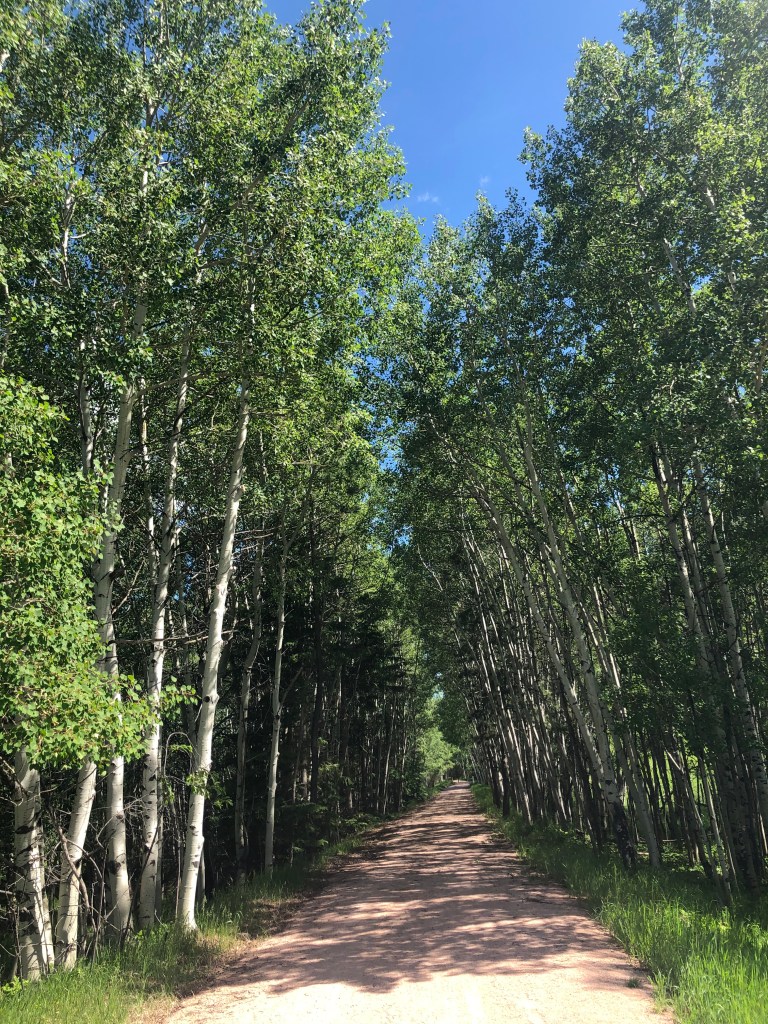
    The terrain is mostly packed gravel which can occasionally give way to areas of loose sand or flat out dirt, depending on the time of year. I recommend a gravel bike or a mountain bike as it is possible to slide around on descents or lose traction in the looser surface on ascents, plus you’ll want gears to adjust your pedaling comfort level.

    How Do I Get There?

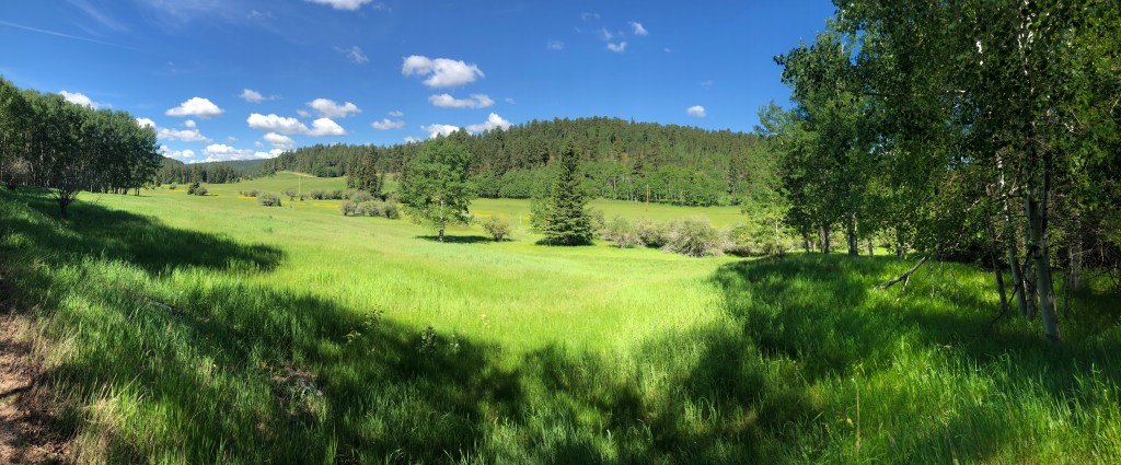
    The Dumont Trailhead is a 10-15 minute drive from Deadwood and about 10 minutes from Lead (pronounced leed). Rochford (pronounced rotch-ferd) Road will take you along some spacious, open fields that are blooming with yellow wildflowers in late spring and early summer. The roadsides can also boast both purple and white flowers depending on the amount of rain the area has seen.

    Upon arrival at the Dumont Trailhead, you will find ample parking. There is also a seasonal portajohn (open Memorial Day to Labor Day) and a picnic table. 

    Important: Please pay your trail access fees before setting off.

    What’s the Ride Like?

    From the trailhead, access the Mickelson Trail by crossing Rochford Road. Deadwood is to your left. Go that way.

    The first part of the journey—a long, steady, uphill grade—can feel like a slog. It’s gradual, though, and it’s worth it, so don’t get disheartened.

    Once you get over that hump, it’s (mostly) all downhill, which may or may not be good news for you. Personally, the last time I rode this portion of the trail, my, shall we say, “nether regions” got numb and I found myself standing up on my pedals or sticking my legs out to the side just to get some circulation going on down there.

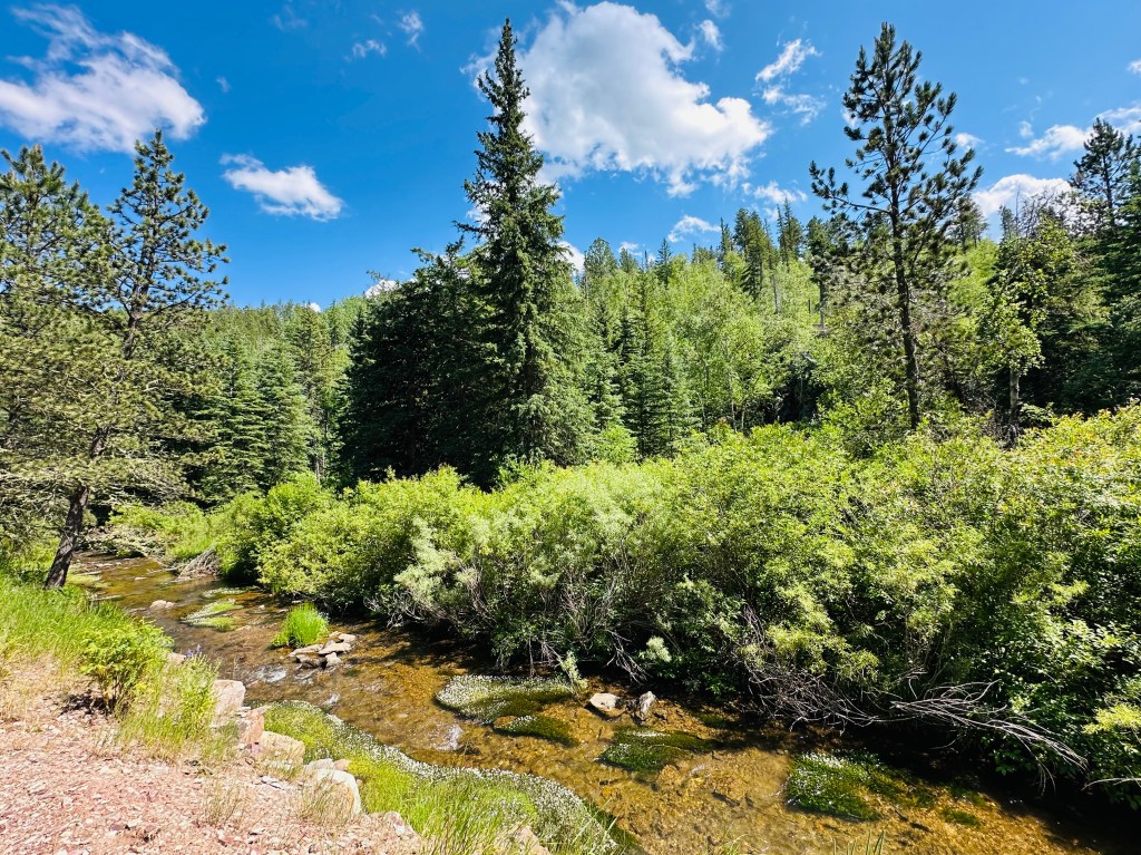
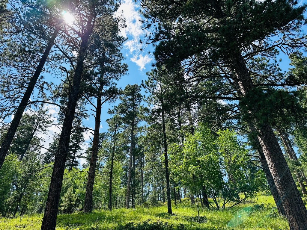
    However, with the breeze tousling your hair and the dappled sunlight strobing through the trees, it’s easy to get the sensation that you’re flying and not just riding. Go slow, though, because the ride is so dang pretty and interesting. Take a moment now and then to appreciate the industrious folks that pushed to get this trail made. Imagine the trains that ran the tracks hidden just under the ground beneath you and how this area might have looked 150 or so years ago—a horse gallumphing your way with a friendly rider atop, halooing you from afar.

    A meadow of wildflowers, just off of the Mickelson Trail outside of Lead, South Dakota.

    Keep in mind that much of the property on either side of the trail is private and encroachment is trespassing. So, resist the dreamy temptation to go a-traipsin’ across those inviting meadows.

    When you’re all through letting your mind wander and ready to get back on your bike, you’ll eventually pass by the Rochford Trailhead, where there is a bench for shade, a bike maintenance station, a portajohn and sometimes a water spigot that isn’t turned off. 

    Not long after the Rochford Trailhead, you’ll encounter a small climb, at the end of which you’ll come to a fork in the trail, literally.

    To Sugar Loaf or Not To Sugar Loaf?

    To the left is a fairly challenging climb via the Sugar Loaf spur trail. This leads to a scenic creekside ride near the outskirts of Lead and you’ll merge back with the Mickelson itself at the Kirk trailhead about ¾ of the way down the spur.

    If you choose to continue your descent, go to the right. The first few hundred yards is bumpy, so take it slow, especially if you’re inexperienced in such moderately rocky terrain. You can easily go ass over applecart if you’re in too much of a hurry (that’s South Dakotan for “over your skis” which is also South Dakotan for “flip over and suffer grievous injuries to your neck/head/back.”)

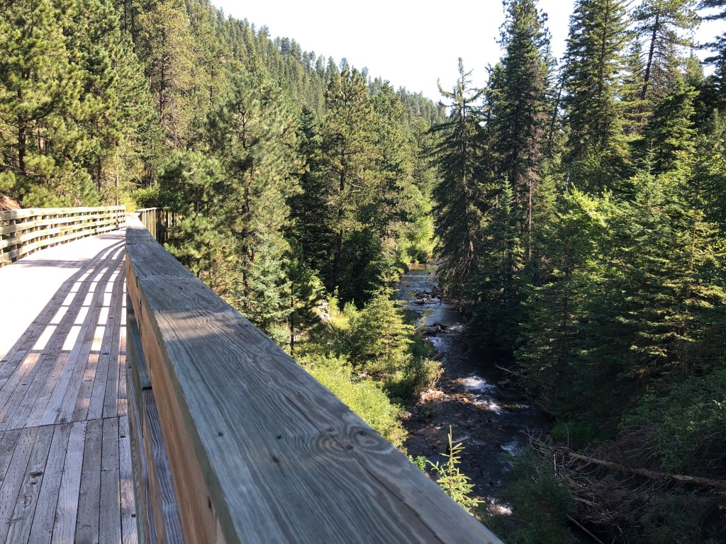
    The advantage to continuing this way is that you’ll go over a series of picturesque bridges and through a unique, though short, limestone corridor where you can catch glimpses of glittering quartz jutting out of the hillsides. Keep your photo-capable mobile device (cellphone) handy. There are also a few pull off spots with benches to stop and rest.

    Regardless which path you choose, the trail will straighten out as you approach an area called Kirk, where there’s still a functional power station up on a hillside. You can also see a few buildings leftover from the Homestake Mine-era looming over you on the horizon. 

    Continue on the trail and you will encounter three road crossings that can be a tad sketchy because of cross traffic and blind corners. Follow the signs and proceed cautiously.

    As you approach Deadwood, you will encounter the most dangerous part of the trail, which is when you cross South Dakota Highway 385. Stop and wait until all of the traffic has cleared or until you are sure that cars have stopped to allow you to cross. I’m never comfortable crossing here, so stay on your toes.

    Soon you’ll hit another, milder road crossing at the entrance to the city of Deadwood. The area should look familiar as you glide through the neighborhoods along the trail. You’ll likely encounter more bikes, joggers and pedestrians with dogs through here. Before long, the trail ends at the Deadwood Trailhead and the parking lot, where you can finally dismount and rest your tired nethers.

    A creekside vista along the George S. Mickelson Trail outside Lead, South Dakota.
    The Mickelson Trail is truly one of South Dakota’s greatest achievements. So, Go Forth, But Tread Lightly.

  • An all-day adventure that highlights the best of what the Black Hills has to offer.
    Entry gate to Pathways Spiritual Sanctuary

    Stay: 

    La Quinta Inn and Suites by Wyndham at WaTiki Waterpark, 1416 N Elk Vale Rd, Rapid City, SD 57703 (605) 718-7000 

    Destinations:

    Needs:

    Two vehicles that can carry bikes, bring or rent gravel or mountain bikes, sturdy shoes, water, snacks, extra layer of clothing for warmth, sunblock (optional: flip-flops/slip-ons for car rides to let your stinky feet breathe a li’l.)

    Costs: (excluding travel, lodging and bike rentals)

    $5 day pass for Mickelson Trail, donation money for Pathways, lunch money at Jacob’s ($15+/ person, prices vary) Watiki passes included with La Quinta stay, money for dinner and drinks ($10+/person) at Slider’s Bar and Grill


    Schedule:

    • Dawn (5:30 a.m.-ish): Awake, curse my very name, continental breakfast at La Quinta.
    • 7:00 – 7:40 – Drive two vehicles to Mickelson Trailhead in Deadwood.
    • 7:40 – Drop second vehicle at Mickelson Trailhead in Deadwood, pile into first vehicle. 
    • 7:40 – 8:00 – Drive to Pathways Spiritual Sanctuary.
    • 8:00-10:00 – Stroll around the Sanctuary, contemplate the meaning of life.
    • 10:00-10:05 – Drive to Dumont Mickelson Trail stop (literally across the highway.)
    • 10:05 -10:30 – Snacks and water at a picnic table. Bathroom break
    • 10:30 a.m. – 12:30 p.m. – Ride bikes to Deadwood
    • 12:30 – 2:00 – Lunch at Jacobs Brewhouse Restaurant
    • 2:00 – 3:00 – Drive the second vehicle to retrieve the first vehicle from Dumont trailhead.
    • 3:00 – Don’t forget, in your tiredness, to return for the locked up bikes, if applicable!
    • 3:00 – 4:00 – Return to Rapid City.
    • 4:00-5:00 – Refresh/stretch/nap at hotel (preferably in your room).
    • 5:00 – 9:00 – Enjoy waterslides at Watiki. Eat dinner poolside from Sliders Grill.
    • 9:00 – Return to room. Crash hard.
    Go Forth! But Tread Lightly.

  • Quick Tips for a Summer Visit to the Black Hills

    So, you’ve booked a trip to the Black Hills. You’ve done some research, know all the spots to hit, know to avoid petting the fluffy cows and know to call those fluffy cows “bison” and not “buffalo.” 

    Now, you need some useful advice on what it’s actually like when you get to the Hills.

    There’s unofficially three general areas of the Black Hills: the Northern Hills (the Spearfish, Lead, Deadwood, and Sturgis area) the Central Hills (the Keystone and Rapid City area) and the Southern Hills (the Custer and Hill City area).

    1.) Plan On a Lot of Driving. A Lot.

    Most places of note in the Black Hills are about an hour away from each other, some more, depending on where you are coming from and where you’re going.

    If possible, bunch your adventures so you can hit places in the same area on the same day. For example, if you are staying in Deadwood and want to see Mount Rusmore, consider planning a trip that includes something you want to see in the Rapid City area while you’re at it.

    Deer are near roadsides frequently at dusk and dawn. But they also pop up a lot after dark, the sneaky buggers. That “deer in the headlights” cliché exists for a reason, so proceed with caution during these times.

    Pro tip: Ambitious schedules make for ambitious disappointment. I recommend keeping your daily goals to two, maybe three grouped sights, maximum. You won’t see everything in one trip to the Black Hills. You may not see everything in one decade.

    2.) Be Skeptical of Weather Forecasts

    In general, pack for just about all weather possibilities. It can snow in August here. It probably won’t. But it sure can. That being said, you don’t need to bring literal winter clothes for a summer trip.

    My opinion is that summer excursions are best started as close to dawn as you can get. It will be a bit cold at first, but it will warm up quickly. So bring a long-sleeved layer. You’ll thank me for it at first, then curse me for it later when you have to take it off and stow it or wrap it around your waist or whatever. That’s a risk I’m willing to take to keep you warm. 

    It can get prohibitively hot in the afternoon. So if you are unequivocally an afternoon person, make sure you bring plenty of water.

    Also, plan for rain every evening in the summer. Fortunately, most storms are over within an hour and usually more like 30 minutes.

    Pro tip: Add each of the locations you’ll be visiting to your weather app. (I even have Lead and Deadwood in my app and they’re three miles away from each other.) Check the forecast AND the radar before you set out. You could easily find yourself in sunny Rapid City while a thunderstorm comes crashing in on Deadwood, where you’re staying. Best to avoid driving in that kind of mess, if you can.

    3.) Be Prepared for Spotty Cell Phone Coverage

    All of the towns in the Black Hills have cell phone coverage, of course. But you don’t have to travel too far outside of town before it drops. Spearfish Canyon and Custer State Park can have little to no cell phone coverage at all. Plan accordingly.

    Pro Tip: Call ahead to make sure the place you’re going to is open that day. You’d be surprised by how many places a) don’t have a website b) don’t bother updating their hours on Facebook or Google or whatever internet thing they rely on for information and c) are closed on Sundays, Mondays or whatever holiday just happens to fall during your trip. This madness is especially true of restaurants, so be warned.

    4.) Go Forth! But Tread Lightly

    Pack in, pack out. Leave no trace. Read and heed posted signs. Most importantly, have fun!


  • Welcome to What’s Good, Black Hills?

    Plan to visit or move to Rapid City, Deadwood, Spearfish, Custer or any of the beautiful other towns in the Black Hills of South Dakota? This website is for you!

    You can expect useful, insightful and entertaining blogs, videos and social media posts about what to expect when you are taking a trip or moving to the the region

    I’m a local and I want to help you find out What’s Good about the Black Hills.

    This website is under construction, but stay tuned. Lots more to come!

    Go Forth! But Tread Lightly.